Friday, August 13, 2010


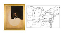
Monitoring the weather this morning, I once again decided to get an early start. The remnants of last night's storm still lingered and light rain was predicted. Leaving Sykesville this morning at 6:45 and facing a half mile climb will wake anybody up. The wet roads made for careful but cool riding. The Liberty Reservoir and Patapsco Valley State Park are beautiful forested areas north of Washington and I passed through them on my route. Many of the small towns that appear on a map in the region are just a gathering of a few houses so I make sure I always carry at least a half gallon of water on board. Actually that has become my standard practice anywhere on my journey. Brookeville seemed to be a bit raveged by the storms as I saw downed trees and power lines throughout the area. However, the 18th century stone buildings seemed indifferent to all the downed branches. In order to enter Washington D.C., there are a series of trails and paths that traverse the otherwise busy main street highways. In order to begin my approach, I entered the Bethesda area from the north through Rock Creek Regional Park. This picturesque wooded preserve also showed signs of storm damage and wreckage. The creeks were swollen and downed trees and mud covered the paths everywhere. This became a 'cyclocross' bicycle event for me to move south this morning. The Rock Creek Trail however, nicely intersects the Georgetown trail at ninety degrees and I connected to this path. This is the perfect alternative to take into the city and it is clearly marked and paved for the most part. It seems to be a local favorite. The old railroad bed that was converted to a bike path reminded me of the nice trail from Cincinnati to Xenia, Ohio. This route moved along the Potomac River and is a great way to get into the Washington Mall. I met a local cyclist who rode the length of the trail with me which deposited us just behind the Lincoln Memorial. I truly appreciated his help in navigating me downtown! The cloud covered cool day was a perfect day to enter the city. After changing a flat at the Memorial, I rode towards the White House on Pennsylvania Avenue! Home free at last. My journey that left Springfield, Illinois at the front door of Abraham Lincoln's home on July 11th took 34 days and covered 2046 miles. I reached the front gate of the White House at 2pm eastern time today!
This has been truly an epic experience that I have to now let settle in and reflect upon. The last 3 weeks of the trip have been a solo journey which required me to be extra vigilant in keeping track of my navigation, equipment and personal well being. I used an Iphone and GPS to navigate and carried 50 lbs of equipment including tools, stove, fuel, sleeping bag, tent, food, and water. In spite of my modern conveniences, I was traveling at a 19th century pace at times. Each landscape I traversed was carefully mapped and paid attention to. I know that while driving a car, it is easy to daydream at times, this is not possible on a bicycle. My awareness for the past 5 weeks has been constantly focused on the present task at hand and this has been the gift of the journey. To see the landscape for what it is and to 'work' the land by moving through it under my own accord revealed a beauty that I took for granted or just did not notice. Many times a farmer would wave as I rode through the spaces. He might not have understood why I was cycling but we both shared in a dialog with the land. I was always aware of the wind, the rain, the weather, and temperature. Though it was hot at times, I truly felt the coolness behind the shade of a silo or an oak tree. This simple experience is what I think has changed the most in the past 150 years. Thinking about what it took to get me to Washington and how much the landscape has changed and how far away Springfield is, I couldn't help but to reminisce about the early morning mist rising from the inland seas of corn in Sangamon County central Illinois. I can't help but think that this kind of longing could quite possibly have contributed, among other things, to Lincoln's melancholy. (Travel was difficult and most people never left the county they were born in.)
In Washington D.C. on March 4, 1861, Abraham Lincoln was inaugurated the 16th President of the United States. I think the address he gave to the people was one of the most profound and eloquent statements a President has made to the nation (and world) at a time of extreme uncertainty and civil violence. I think it is a good reminder for us for today as well. I memorized the last paragraph of his address and discovered something interesting. It was difficult to put to memory. What I mean is that usually it is easy to pick up the meter of a verse and then automatically fill in the words based on the syntax of the writer. I couldn't do this because of the particular pauses in the prose. True, Lincoln's writing was influenced by Shakespeare and the Bible, but I believe that there was also a direct influence of the central Illinois landscape,- a tree appears as an island, and then it is not and it reveals it is actually part of a grove. Maybe a slight turn in the road shifts for no apparent reason other than to mark a county line. This landscape is about pauses and reflection, and that is how I read it. I felt like I was learning to see the landscape throughout my journey in this manner. It was truly a lesson in learning and listening.
_________________________________
"We are not enemies, but friends. We must not be enemies. Though passions may have strained it must not break our bonds of affection. The mystic chords of memory, stretching from every battlefield and patriot grave to every living heart and hearthstone all over this broad land, will yet swell the chorus of Union, when again touched, as surely they will be, by the better angels of our nature."
[A.Lincoln, 1st Inaugural Address]
_________________________________
I would first and foremost like to thank Amy, my wife, for her love and support on my journey, and my son, Anders, (who rode from Springfield to Cincinnati with me) and my daughter Julia (also a cyclist). Also thanks to my sister JoAnn's great text messages, Mark and Pat Cleveland (great friends, supporter, texters and riding partner from Cincinnati to Cleveland), And thanks for the support and great text messages from Trudy Welker, Marilyn Ferris, and the Ferris clan! Also, I truly appreciate the blog commenters all along the way! And thanks to Perimater Gallery, Chicago, and the Illinois Institute of Art, Chicago, Dr. Jeffrey Allen, Vesna Grbovic, and Michael Robinson.
I also want to thank the Abraham Lincoln Presidential Library and Museum in Springfield, Illinois with help in shouting this project out. Also thanks to Dave Bakke at the Springfield Journal Register, WGRZ/CBS and WKBW/ABC in Buffalo, New York, NBC and Fox News in Philadelphia, and KYW Newsradio 1060 in Philadelphia for your attention.
________________________________
In the spirit of "the better angels of our nature", I am also collecting a 'penny per mile' for the Livestrong Foundation to support Cancer research. If you wish to contribute please send a check made out to the Livestrong Foundation in any amount to Illinois Institute of Art, Chicago, c/o Don Pollack, 180 N. Wabash Avenue, Chicago, Illinois 60301. -If anyone wishes to match a 'penny per mile' that would amount to $20.46. (I will bundle the mailing in one envelope)
I plan on creating an exhibition out of this project, "Taking Measure Across America" and most likely will announce it on this blog. It will appear on my website as well, www.MuseumInTrust.com
Thursday, August 12, 2010


I thought by getting up at 5am and eating an early breakfast, I could beat the storms that were heading across the eastcoast. Not so, as I started off wearing rain gear at 6:45 this morning. The rolling hills of Maryland could well have been central Illinois on the high plains when it comes to a lightening storm. Fortunately, I rode into Rocks State Park and found shelter underneath the overhang of a small stone building. It actually was a perfect place to wait out a storm. After the rain passed the partly cloudy weather yielded a 72 degree day! The country roads through Maryland were beautiful to ride through. There are rolling hills, farms, and forests throughout this state. At times, the tall white pine groves reminded me of upper peninsula Michigan. Crossing over a ridge, I rode through an area of low lying conifers and rock debris that reminded me of eastern Washington state. That terrain eventually gave way to wooded rolling hills, neat white fences, and then horse farms.
Unfortunately for Lincoln, he had to quietly pass through Maryland on his way to Washington. Allan Pinkerton, the founder of a detective agency in Chicago was hired by the railroad to investigate suspicious activities and the destruction of railroad property. Convinced that there was a plot to assasinate the President elect, he had the telegraph lines cut to shut down any possible communication between co-conspirators. At night a second train carrying Lincoln was quietly pulled through Baltimore by horses (so as to not violate a city ordinance) and it entered Washington the next day. The scheduled official train arrived in Baltimore as planned but only carrying Mrs. Lincoln and the children. Lincoln regretted this event and in retrospect his actions seem opposite of the bold confidence he displayed in Philadelphia. Perhaps Pinkerton was right to discreetly shuttle Lincoln through this state,- it's so many personalities make it difficult to type cast and understand at a glance. I think Maryland appears rural and urban as well as southern and northern simultaneously,-especially in it's beauty of the landscape.
Unfortunately for Lincoln, he had to quietly pass through Maryland on his way to Washington. Allan Pinkerton, the founder of a detective agency in Chicago was hired by the railroad to investigate suspicious activities and the destruction of railroad property. Convinced that there was a plot to assasinate the President elect, he had the telegraph lines cut to shut down any possible communication between co-conspirators. At night a second train carrying Lincoln was quietly pulled through Baltimore by horses (so as to not violate a city ordinance) and it entered Washington the next day. The scheduled official train arrived in Baltimore as planned but only carrying Mrs. Lincoln and the children. Lincoln regretted this event and in retrospect his actions seem opposite of the bold confidence he displayed in Philadelphia. Perhaps Pinkerton was right to discreetly shuttle Lincoln through this state,- it's so many personalities make it difficult to type cast and understand at a glance. I think Maryland appears rural and urban as well as southern and northern simultaneously,-especially in it's beauty of the landscape.
Wednesday, August 11, 2010


The mist over the fields was so thick this morning that my handlebars felt wet to grab. The farms had laundry hanging on the line that I didn't think would ever dry. Next to a field being plowed by a man using four horses and a gas cutter, I saw a young boy wearing plain work clothes and a straw hat rollerblading. The Menonnite people in this part of Pennsylvania appear to be a liberal lifestyle version of the Old Order Amish I saw in Ohio. Neat homes and stone buildings seem to be the norm. Cycling along a ridge I was a little concerned with it's name being 'Furnace Hills'. I didn't want them to live up to their moniker. Moving west and then south I rode for a while along the Susquehanna River. Boats and docks lined the water's edge and it's size in places seemed more like a lake. Riding here was great on 'Long Flat Road'. But, that only lasted briefly as my southern path had to climb another ridge. It was nice to be in the trees and the houses on this stretch of the road were perched close together with streams flowing nearby. It reminded me of old places I had seen in West Virginia with the only difference being the use of stone to build foundations and retaining walls. I passed a place called Donegal and the stonework made sense. The scale of these buildings were 18th century and the people who built them must have been early Irish immigrants. My day's ride took me to the southern edge of the state line. Tomorrow I enter Maryland and will skirt around Baltimore's western edge. Lincoln had to do the same but for different reasons. He wanted to change trains here quietly and avoid confrontation with antagonistic people from this northern but slave holding state. His task would be to prevent insurrection and keep Maryland solidly in the Union.
Tuesday, August 10, 2010


This morning at 7am the air was thick and humid. I could tell this was going to be a challenge from the start. Leaving Philadelphia from the Conshohocken bike path along the Schuylkill River however, was very easy and quick. The still waters followed me along a parkway void of car traffic. Leaving the path, I followed another path into Valley Forge National Historic Park. The rolling hills and stone barns and houses stand as stoic reminders of the battle for independence. Washington's headquarters is just off the main road. Though the path is seperate from car traffic, it is odd to see comuter traffic run through the park. This still does not disturb the quiet beauty of the fields and it is difficult to imagine cannon fire in what looks like prime farm country. As I left the area, my route took me further into the forest. As the day went on the fields seemed more remote and the forest thicker. I thought I should keep my eye out for black bear. Deer were abundant in the area and I had to carefully ride around one as he just stood in his tracks and looked at me.
This is Lancaster county, Pennsylvania and the elavation will not let a cyclist forget it! Combining this with 95 degree heat, I carefully monitored my water intake! Pennsylvania is an old state. Continental Armies waged war with the British Empire, the Confederacy launched attacks into it's homeland, and the battle with Native Americans began here before all this. The landscape holds these memories and knows that struggle is part of it's heritage. Stopping in Reamstown for the day, I am made aware of it's 250 year old history too. Just southwest of here, Lincoln commemorated another space in Pennsylvania. Speaking for what amounted to all of two minutes, his speech at Gettysburg eloquently framed and outlined what would become a new vision for a modern America.
This is Lancaster county, Pennsylvania and the elavation will not let a cyclist forget it! Combining this with 95 degree heat, I carefully monitored my water intake! Pennsylvania is an old state. Continental Armies waged war with the British Empire, the Confederacy launched attacks into it's homeland, and the battle with Native Americans began here before all this. The landscape holds these memories and knows that struggle is part of it's heritage. Stopping in Reamstown for the day, I am made aware of it's 250 year old history too. Just southwest of here, Lincoln commemorated another space in Pennsylvania. Speaking for what amounted to all of two minutes, his speech at Gettysburg eloquently framed and outlined what would become a new vision for a modern America.
Monday, August 9, 2010


Leaving Milford this morning to a cool breeze was a great welcome! The Delaware River was still as glass and reflected the shoreline in perfect symmetry. Not too far from my location Washington crossed this river and signs remind me of the mileage to Valley Forge. A different century for my project and I have to keep focused on my mission as I could easily spend time at all of these sites. Heading south along the New Jersey side of the river, I am riding on a road that looks cut out of rock on the east side. Signs remind me to watch for falling rock and I see brick size debris that would not be a welcome event for bicycle or car. The area feels remote in the early morning and I have to remind myself I am not far from Trenton and New York city. These spaces defy my previously conceived notions of what this area of the country should look like. Stone houses from the 18th century hug the sides of the rock walls and they seem rather unassuming. These are not fancy rehabs or historical registry houses but they appear to be ordinary residences that were perhaps passed down to family members. The towns that pop up by the river crossings all have a bridge street and the roadway narrows to suggest their original design for carts and horses. I eventually cross into Pennsylvania on the west side of the river and come up on stone ruins of an old barn. This whole area has remnants from previous centuries and all of this seems quite foreign to a midwesterner.
The approach into Philadelphia is very easy. This is a bicycle friendly city,-even in the downtown area. Bike paths lead into the city proper and bike lanes traverse the the heart of the downtown streets. William Penn's 17th century design for the Center Square creates a dramatic view. The European roots of his thinking are obvious as I ride around a huge circle by the art museum to traverse the route. The 'Second Empire' style of architectural design for City Hall commands the center space and though it was completed in the early 20th century, it still speaks of history. As I move towards Independence Hall, the several block area becomes part of the National Park Service grounds. These are highly guarded spaces of national importance. Armed guards are outside the site where Lincoln stood by the Hall as well as across the street by the Liberty Bell. On February 22, Washington's birthday, Lincoln responded to death threats on his life by raising an American flag at Independence Hall. His gesture was intended to demonstrate that the Union and the principles that it was founded upon, would be preserved. Having to go through security checks and not being allowed to bring my bicycle and equipment through, I thought that I would miss getting close to this site. The guards brought over the head ranger and I explained my project of retracing the inaugural train route. I also showed him my gallery card of the Lincoln portrait I painted for the Abraham Lincoln Presidental Library and Museum in Springfield, Illinois. He was generous in his understanding and gave me a special escourt to the Lincoln site so I could photograph the space. I wish to thank him and the National Park Service for their generosity! Across the street on the east side of Independence Hall is ironically, the Gilbert Stuart house. Having painted Lincoln in the style of Stuart's half finished Washington portrait and showing my gallery card of the image, I couldn't help but think that the turn of events today was influenced by a collaboration of Mr Lincoln and Mr. Stuart.
The approach into Philadelphia is very easy. This is a bicycle friendly city,-even in the downtown area. Bike paths lead into the city proper and bike lanes traverse the the heart of the downtown streets. William Penn's 17th century design for the Center Square creates a dramatic view. The European roots of his thinking are obvious as I ride around a huge circle by the art museum to traverse the route. The 'Second Empire' style of architectural design for City Hall commands the center space and though it was completed in the early 20th century, it still speaks of history. As I move towards Independence Hall, the several block area becomes part of the National Park Service grounds. These are highly guarded spaces of national importance. Armed guards are outside the site where Lincoln stood by the Hall as well as across the street by the Liberty Bell. On February 22, Washington's birthday, Lincoln responded to death threats on his life by raising an American flag at Independence Hall. His gesture was intended to demonstrate that the Union and the principles that it was founded upon, would be preserved. Having to go through security checks and not being allowed to bring my bicycle and equipment through, I thought that I would miss getting close to this site. The guards brought over the head ranger and I explained my project of retracing the inaugural train route. I also showed him my gallery card of the Lincoln portrait I painted for the Abraham Lincoln Presidental Library and Museum in Springfield, Illinois. He was generous in his understanding and gave me a special escourt to the Lincoln site so I could photograph the space. I wish to thank him and the National Park Service for their generosity! Across the street on the east side of Independence Hall is ironically, the Gilbert Stuart house. Having painted Lincoln in the style of Stuart's half finished Washington portrait and showing my gallery card of the image, I couldn't help but think that the turn of events today was influenced by a collaboration of Mr Lincoln and Mr. Stuart.
Sunday, August 8, 2010


While I researched the route Lincoln's inaugural train took, I thought at first, I must visit every city exactly on the path. Well, I was surprised when I discovered a list of every marker that every town along the way has displayed,- there are literaly hundreds of plaques in small towns acoss the country. Some were on the inauguration route and some were on the funeral train route and some were on both. Sometimes the train just stopped briefly to service the locomotive and sometimes a town's claim was to just have had the train merely pass through. I decided my journey would be the inauguration route to focus on the rise of Lincoln. Also, there was something that seemed a bit ironic, geographically speaking. Let me explain. From the time of Daniel Boone forward, as Americans, we saw ourselves moving westward. This always symbolically stood for opportunity in the American psyche and to the Hudson River painters as well,- the horizon line in their landscapes metaphorically was the west. Lincoln however, was a person from the west who went east as he rose to national importance. The way he challenged slavery proponents was to logically demonstrate that it was labor that generated wealth, not just status and inheritance. He can be identified with having defined a contemporary notion of the 'American Dream' and yet his geographic path runs the opposite direction of our mythical path of Manifest Destiny (the 18th & 19th century vision of a country between two Oceans). As I myself have been moving east and now south, I am struck by how the notion of the 'west' is actually east for some people. The landscape in the east can be just as wild, dangerous and beautiful as our expectations of our 'wild west'. Moving along my path I have seen an abundance of wildlife and natural beauty along a thin narrow corridor (Delaware Water Gap) between New Jersey and Pennsylvania. Today I was in an approach through a mountain gap that I could have sworn was the Big Thompson River in Colorado. Traveling by bicycle has slowed me down not only academically (in order to study a 19th century person) but also mentally. I am not so fast to judge the merit of a regional location. I have moved along historic paths and natural paths and yet I am always humbled by an exhausting climb or an empty water bottle or a low food supply. These are items I know I have taken for granted when I'm in my normal day to day routines. They seem to be in an inexhaustible supply to my modern eyes. I saw a letter in a museum case not too long ago that appeared to be 150 years old and had been written on in one direction and then turned ninety degrees and written on in the other direction in order to save paper. To me this seemed amazing and equally so that Lincoln came from a time that did these sort of things. Being able to identify my own limitations and make do with what I have at the moment has been the gift and lesson of my journey so far, especially when climbing a hill today that felt like Pike's Peak in the Rocky Mountains.


Saturday, August 7, 2010
Today is my rest day, so I'm only going a short distance to stay at Dingman's Ferry, Pennsylvania by the Delaware Water Gap National Recreation Area on the Delaware River. It so happens that Dingman's Ferry also has the only privately owned toll bridge left (bicycles are free to cross). In 1735 Andrew Dingman built a flatboat to transport people across the Delaware River and in 1836 the family built the first of many toll bridges. Eventually, private engineers took over the project and in 1900 built the bridge that remains today.
Lincoln's inaugural train actually moved across the Delaware River after leaving Trenton, New Jersey en route to Harrisburg, Pennsylvania. In the interest of cycling a safe path, I will pick up Lincoln's route to Philadelphia.
Lincoln's inaugural train actually moved across the Delaware River after leaving Trenton, New Jersey en route to Harrisburg, Pennsylvania. In the interest of cycling a safe path, I will pick up Lincoln's route to Philadelphia.
Friday, August 6, 2010


Subscribe to:
Posts (Atom)